Prompted by a video by the YouTube creator CGPGrey about the US highway system, mainly centered around its numbering scheme, I was inspired to begin working on a similar project centered around Highway systems from other countries, starting with the countries I am most familiar with, first being Germany. My plan is to eventually create an animated video presenting this in a graphically more interesting way.
- Numbering Scheme & Signing
- Noteworthy Highways
- Trivia
- Differences to other countries
- Sources
- Future Plans
Numbering Scheme & Signing
German Highways are assigned a number, ranging from one to three digits,
prefixed by the letter A (for “Autobahn”). Officially, they are called
“Bundesautobahn” (short “BAB”, for “Federal Highway” or “Federal Motorway”).
The prefix is however not denoted on signs. Highway signs feature a white number
on a blue background and a hexagonal white border.

Sign for the A42 highway, ranging from Kamp-Linfort to Dortmund
The number of the highway usually designates its importance and cardinal direction. Single digit numbers denote highways which reach across large parts or the whole country, double-digits are usually traveling within state borders or only cross into neighboring states, three digits are reserved for regional or city-local roads, like bypasses or access roads to larger highways.
Highways with even numbers usually travers the country in a vertical (meaning North-to-South) way whereas odd numbers usually run horizontally (East-to-West).
For highways with two or three digits, the first digits is defined based on the larger region it is located in.
Noteworthy Highways
Longest single-digit highway
The longest cross-country highway is the A7 ranging from the border city of
Flensburg bordering Denmark’s E45 in the North to the Bavarian city of Füssen
bordering Austria and it’s B179. The A7 covers a distance of 962 km
(598 mi). A7 is also part of the European Route network being part of the
5190 km (3224 mi) long E45 (ranging from Alta, Norway to Gela, Italy) as well
as E43, E532 and the 8778 km (5452 mi) long E40, ranging from Calais,
France all the way to Ridder, Kasachstan.
Shortest single-digit highway
The shortest single-digit highway is the A5, covering 440 km (273 mi) from
Niederaula in Hesse to the border city of Weil am Rhein, connecting
to the Swiss A2/E35 to Basel.
Gaps
Various highways, even single-digit ones, have larger gaps in them, meaning they end in one spot and start again later.
A4
For example, the A4 starts in the West in Aachen, bordering the Dutch A76
to Heerlen, but then ends in Krombach, restarting at the “Kirchheimer Dreieck”,
which branches off the A7, and then continuing all the way to the Polish
border, ending in the German-Polish town of Görlitz / Zgorzelec and connecting
to the Polish A4 connecting to Wrocław. The A4 was also one of the Transit
routes traversing the DDR (GDR) before the German reunification.
The A8 starts from the Austrian border near Salzburg, connecting from the
Austrian A1 in Bad Reichenhall, and stops in München (Munich), entering in
the ring road B2R. It continues on the other side of the city at Schloss
Blutenburg, without being connected to the ring road, ranging over Stuttgart to
Karlsruhe, where it ends for a second time, connecting to the A5. The last leg
of A8 starts in Primasens, connecting to A62 in the north, following the
French border and reaches to the Luxembourgian border connecting to A13 near
the town of Schengen.
A98
Another remarkable highway is A98, as it stretches over only 47 km (29 mi),
another 34 km (21 mi) are currently being planned (as of February 2021).
The first segment starts near the southern end of A5, branching off in
Weil am Rhein and ending in Rheinfelden, ranging only about 17.8 km (11 mi).
The next section is a relabelled 3-lane road providing a bypass to villages
along the Rhein river starting after Bad Säckingen and ending after 10 km
(6.2 mi) short after Luttingen. This section is also co-labelled as B34 and
E54 which continues further.
The third section provides a bypass for the village of Waldshut-Tiengen, ending
again after only 7.3 km (4.5 mi) in Lauchringen, rejoining the B34. This leg
passes partially under the village, providing mostly two lanes.
The last leg of A98 starts at Kreuz Hegau, branching off the A81 and ending
in Stockach near Lake of Constance after about 12.7 km (7.9 mi) merging into
the B31n and B31 which follows the lake south.
Shortest labelled and operational BAB
The shortest, as “Bundesautobahn” labelled and operational highway in Germany
is the A831 in Stuttgart, connecting the Bundesstraße B14 with the A8 and
A81. It also only has one exit, “(1) Stuttgart-Vaihingen” before ending in
the “(2) Kreuz Stuttgart”.
Other shorter highways exist, only having a length of about 1 km (0.6 mi) but
these were officially relabelled as mostly branches of existing larger highways.
Some examples are the A102, being merged with the A100 Berlin city
ring, and the A105, being merged with the A111 connecting to the A10
outside of Berlin.
A999 / A99
The highest number for a German highway, A999 has been assigned to a
highway project in München. A999 was planned to be a highway ring which has
however not implemented. Parts of it was executed under the B2R ring road.
A highway ring was implemented with the A99.
The A99 ring has never been fully completed. It currently spans about two
thirds around the city, starting in the west branching off the A96, crossing
A8, A92, A9, A94 and ending at a crossing between A8 and A995, which
heads back into the city center.
Trivia
Germany only has one direct highway connection to Denmark, that being the A7
in Flensburg. The other highway connection, A1, ends in Heiligenhafen and
continues as E47/B207 onto the German island of Fehmarn in the Baltic Sea.
E47 connects to the Danish island of Lolland via ferry.
Differences to other countries
The US practise of referring to a highway / interstate with its number and a
cardinal direction (i.e. I-40 S for Interstate 40, southbound) is uncommon
in Germany. It is common to refer to them via their number and one of the major
cities en route. For example, a person traveling on the A7 northbound will
refer to it as “A7, Hanover to Hamburg”. This notation is also used in traffic
announcement broadcasts, giving travelers the highway, direction and general
location of an incident. In more local settings, exit names are also added.
A560, Hennef towards Saint Augustin, between Niederpleis and Siegburg, a spade is lying on the road. […]
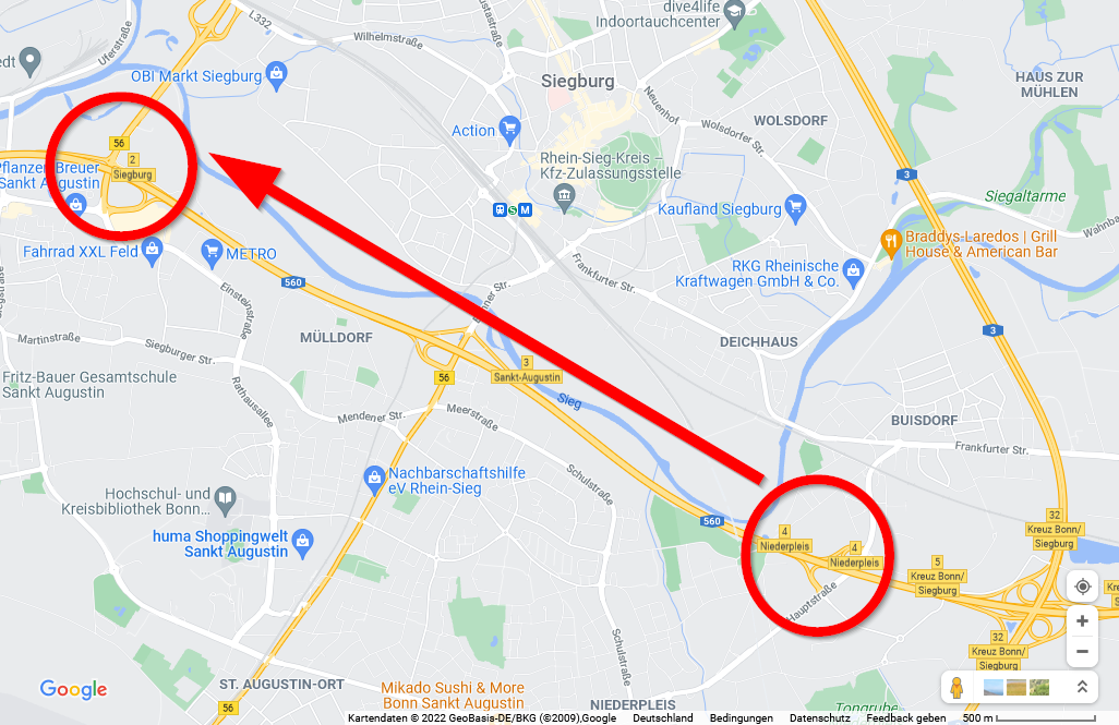
Markings on a screenshot of Google Maps, denoting the area of danger
In this example, the radio broadcast warns us that a spade has been found lying on the highway, posing a threat to drivers. It has been found between the two marked exits on the westbound route.
A2, Hannover towards Dortmund, between Bad Eisen and cross Bad Oeynhausen more than 10 km [traffic].[…]
A3, Arnhem towards Cologne, between cross Oberhausen and cross Kaiserberg 10 km [traffic], more than 20 minutes.
These two examples warn drivers about traffic jams and estimated delays when traversing this section.
sample transcript from a German radio broadcast, translated from German, Source
Sources
Most of this article has been created based of the List of autobahns in Germany (English version) Wikipedia article and its references, as well as public map data.
Future Plans
Next countries on my list to cover are
- Switzerland
- Austria
- Netherlands
- Denmark
- Sweden
- Norway
as well as the European Routes, since they will be mentioned again.